Pikalert and the I-70/75 Aurora Pooled Fund Project
A winter storm moving across the Midwest doesn’t care when it crosses a state line, but it matters to travelers and transportation agencies because they rely on information to navigate through the event.

Sudden disruptions in how states share information can cost transportation agencies time and may affect the safety of travelers. Along major interstate corridors, from state to state, travelers may encounter changing guidance, different alerts, and inconsistent situational awareness updates.
As Curtis Walker, Scientist V for the Transportation Meteorology Applications Program with NSF NCAR explains, “Weather impacts do not stop at state boundaries. Many transportation agencies rely on their own unique set of tools to maintain safety and mobility, and this can degrade a traveler’s experience when transitioning from one state to another.”
The Interstate 70/75 Aurora Pooled Fund project was launched to address this challenge head-on by testing whether a shared, multi-state decision-support tool could improve situational awareness and continuity along two of the nation’s most critical interstate corridors. At the center of this effort is Pikalert®, a road weather decision-support system designed to deliver consistent, real-time alerts across jurisdictions.
A Multistate Approach to a Shared Problem
The I-70/75 Aurora Pooled Fund project is part of a broader multistate partnership under the Aurora program, which focuses on advancing transportation technologies through pooled investment and collaboration. Pikalert was derived from original investments by the Federal Highway Administration’s Road Weather Management Program in the early 2000s and has continued to be refined to meet the growing needs of multi-state travelers.
The goal of Pikalert in this project is to deploy, implement, and evaluate a consistent baseline road weather tool across multiple states, rather than relying on a patchwork of state-specific systems. The project’s main users are transportation agencies in Utah, Colorado, Kansas, Missouri, Illinois, Ohio, and Michigan that participate in the Aurora pooled fund along these corridors.
The Pikalert tool provides a shared view of real-time and forecasted road weather conditions. By using the same platform along major interstate corridors, participating agencies aim to reduce discontinuities in information and improve the overall traveler experience — especially during rapidly evolving weather events.
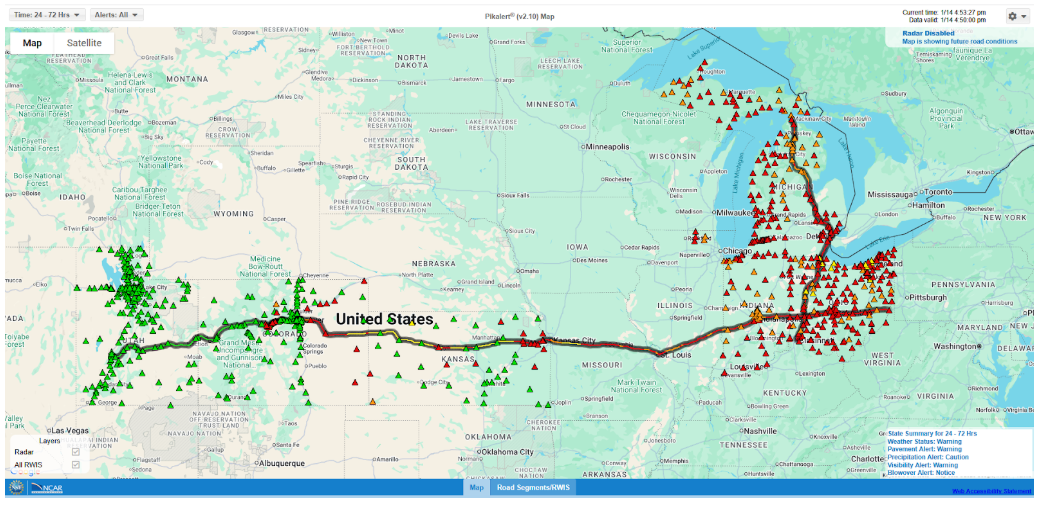
The I-70/75 corridor was an ideal testbed for Pikalert because of the diversity of weather conditions it experiences. “This corridor truly experiences a wide range of weather challenges, from winter and terrain impacts in the mountains of Utah and Colorado, to high winds and blowing dust in Kansas, freezing rain across the Midwest, and lake-effect snow in Michigan,” said Walker.
This range of conditions makes it difficult for any single system to perform well everywhere. The project offered an opportunity to evaluate whether Pikalert could reliably capture and alert for a wide variety of hazards using a unified framework. The key strengths of the project are its ability to integrate observations from various sources (e.g., weather radar, surface observations like ASOS and RWIS, connected vehicle data, traffic camera images) and forecasts from a blend of numerical weather prediction models to provide alerts and assessments of real-time and future weather conditions.
The Role of Data Integration — and Why It Matters
One of the major challenges in deploying Pikalert across multiple states was data integration, particularly for Road Weather Information System (RWIS) networks.
In single-state deployments, Pikalert teams typically work directly with agencies to integrate RWIS feeds. This process is manageable, but resource- and time-intensive. Scaling that approach across multiple states simultaneously, while preparing for the 2025–2026 winter season, required a more efficient solution.
By using Synoptic’s Weather API, the Pikalert team was able to streamline data ingest across multiple state road weather networks through a single integration point. Synoptic provided data aggregation to bring multiple RWIS feeds together into one platform where it could be easily accessed by Pikalert. This enabled faster deployment and reduced the burden on project partners.
According to Walker, “Working with multiple states at the same time required a more efficient approach. Synoptic was a one-stop shop and streamlined our RWIS integration workflows and handled the work needed to bring new state RWIS networks online.”
As with any large, multi-state project, there were technical challenges. While Pikalert became operational in November 2025, early in 2026, changes to some state RWIS data feeds resulted in inconsistencies that were not immediately apparent. In addition, familiarizing the Pikalert team with available data fields, such as road friction or grip measurements, which vary by state, required additional coordination. “Synoptic has been able to keep access to the data consistent and reliable by interfacing with the data providers to ensure the data is available for the program,” said Walker. The technical challenges highlight both the complexity of multi-jurisdictional data integration and the importance of ongoing communication between data providers and system developers as networks evolve.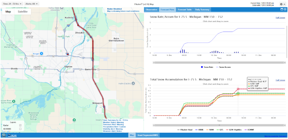
RWIS data are essential for Pikalert, and real-time awareness of current road and atmospheric conditions allows forecasts and alerts to be tuned with on-the-ground observations. Having access to the data from a reliable, single source ensures the information is consistent and up-to-date for operating the program.
Looking Ahead: A Model for Future Collaboration
While winter 2025–2026 has been relatively quiet across much of the study domain so far, the project has already generated strong interest at NSF NCAR. The results will help inform future decisions about expanding Pikalert coverage and identifying opportunities for broader cross-state collaboration.
“Our hope is that agencies look for more cross-state and cross-jurisdiction opportunities to provide seamless, consistent information using baseline tools like Pikalert,” said Walker.
As Pikalert continues to expand, Synoptic is proud to be a strategic partner for supporting efficient data integration and a key partner for future road weather initiatives, especially when they extend beyond individual state boundaries.