Aircraft-Based Observations
As the primary reseller for FLYHT’s TAMDAR and AMDAR-over-AFIRS data, Synoptic is bringing these powerful aircraft-based observation datasets to new users and applications worldwide.
Why Aircraft-Based Observations (ABO)?
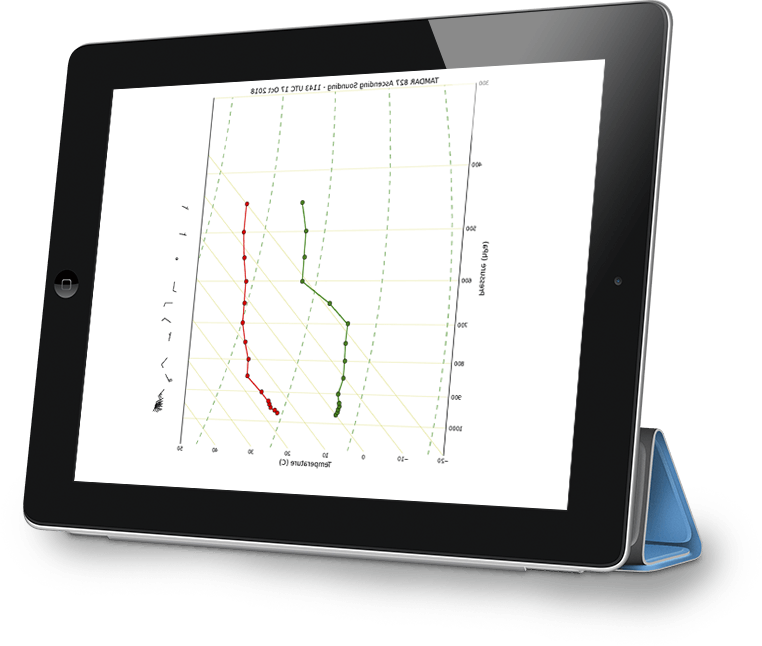
Aircraft-Based Observation data has been shown to be one of the top five most important datasets (measured by impact per observation) for regional and global Numerical Weather Prediction (NWP) models. This conclusion has been clearly demonstrated during the global COVID crisis, during which the decrease in aircraft-based data reduced global NWP accuracy by more than 20% in some analyses. These aircraft data provide tremendously valuable information in the vertical in the form of a sounding — vertical profiles of temperature, wind, and in TAMDAR’s case, moisture.
What is AMDAR?
The Aircraft Meteorological Data Relay (AMDAR) program was initiated by the World Meteorological Organization (WMO) and is now a global program that includes more than 40 commercial and cargo airlines. AMDAR uses the aircraft’s own installed sensors to measure wind (direction and speed) and temperature as well as altitude and GPS position during take-off, landing, and cruise. AMDAR data is transmitted to the ground for compilation using the aircraft’s VHF communications suite. Data is available in real-time to National Meteorological and Hydrological Services (NMHSs) agencies and to the sponsoring airline, and is available to all others on a 48-hour delay. For more information on the AMDAR program, please click here.
What is TAMDAR?
Synoptic partner FLYHT’s Tropospheric Airborne Meteorological Data Reporting (TAMDAR) system is currently installed on regional commercial aircraft from a dozen airlines serving North America, Asia, and Europe, providing tens of thousands of observations throughout the boundary layer on a daily basis. Using Iridium satellite communications, this groundbreaking sensor is an after-market install and measures atmospheric conditions during take-off, landing, and cruise phases of a flight. TAMDAR measures wind speed and wind direction, temperature, moisture, pressure, ice detection, and turbulence and transmits them to the ground, where they are available to subscribers in real-time. TAMDAR also acts as a flight tracking mechanism that records a GPS position in both time and space with every observation. For more information on TAMDAR, please click here.

What is AMDAR-over-AFIRS?
FLYHT’s proprietary Automated Flight Information Reporting System (AFIRS) is an Iridium-based satellite communication device that acquires and transmits aircraft operating data, including many aircraft operational parameters as well as wind and temperature measurements, and delivers that data to the ground in real-time. It is currently installed on regional commercial and cargo aircraft throughout North America, Europe, and Asia with some flights into South America, Africa, and Australia. AMDAR-over-AFIRS refers to the transmission of the measured wind and temperature data (the same as AMDAR reports) via AFIRS, with the two significant differences being the communications path and the fact that AMDAR-over-AFIRS data is available to non-NMHS subscribers immediately, without the 48-hour delay associated with AMDAR. For more information on AMDAR-over-AFIRS, please click here.
ABO Data and Numerical Weather Prediction (NWP)
Numerous joint-collaborative studies between NOAA, NASA, the FAA, and the research community have been conducted to demonstrate the use and efficacy of ABO data in NWP. In some cases, ABO data can even be tailored to better support NWP. For instance, the vertical and temporal resolution for TAMDAR observations is completely adjustable, allowing for extremely high resolution data in the vertical during takeoff and landing where it has the most positive impact on NWP modeling. This yields a fully customizable solution allowing greater vertical and temporal frequency than either traditional AMDAR or radiosondes. TAMDAR and AMDAR-over-AFIRS data are delivered and available in real-time. TAMDAR and AMDAR-over-AFIRS data go through rigorous quality control (both real-time and on the ground) to ensure they meet strict standards.
Beyond NWP, ABO data has use in machine learning/artificial intelligence as well as situational awareness both for forecasters and other user groups such as national security/emergency management, air quality, and airport operations.
Synoptic ABO Partners vs. Radiosondes
Since the late 1930s, the gold standard for upper-air data has been the balloon-launched radiosonde. Radiosondes continue to contribute valuable information, but they are now limited to twice daily launches at 00Z and 12Z at just 92 stations across the United States (including Alaska, Hawaii, and Puerto Rico), leaving large temporal and spatial gaps in data coverage. Synoptic’s ABO partners fill these gaps as each plane essentially becomes a radiosonde, gathering upper-air data during each portion of the flight (ascent, descent, and cruise).
Soundings are collected every time a plane takes off and lands, which could be 15 or more times a day, yielding tens of thousands of soundings a day. Soundings are collected at every airport that an ABO partner equipped plane flies into or out of, not just at fixed locations like radiosonde launches. In addition, TAMDAR measures turbulence and icing, which a radiosonde does not. Radiosondes are costly to deploy and are usually one-use only equipment whereas aircraft can be used continuously for a decade or more. This leads to greater cost-savings for the data provider and data user alike. Combined, Synoptic’s ABO partners provide more than 5x the amount of data available via the traditional AMDAR program.