When wildland fire crews are working in complex terrain, knowing exactly how wind will behave is crucial for staying ahead of a fire, predicting where it will advance, and planning resources accordingly. Wind modeling is a valuable tool for fire weather monitoring and understanding fire behavior. That’s why WindNinja was created — to provide high resolution wind information and modeling to improve operations in the field.
Developed by the USDA Forest Service’s Missoula Fire Sciences Laboratory, WindNinja is an open-source, public-domain software tool that generates high-resolution wind maps for any location on Earth. Since its release, it has been used in millions of simulations across 72 countries by over 6,000 users.
How Does WindNinja Work?
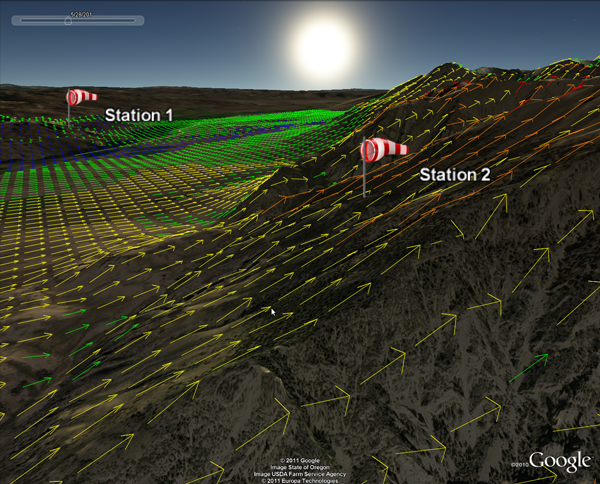
WindNinja can be run in three different modes, depending on the application and available inputs. The first mode is a forecast, where WindNinja uses coarser resolution mesoscale weather model data from the National Weather Service to forecast wind at future times. The second mode uses one or more surface wind measurements to build a wind field for the area. The third mode uses a user-specified average surface wind speed and direction. Other required inputs for a WindNinja simulation include elevation data, date and time, and dominant vegetation type.
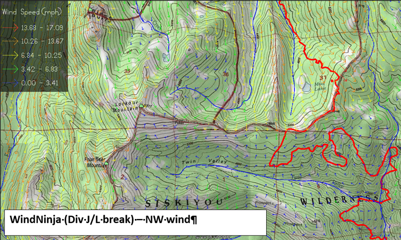
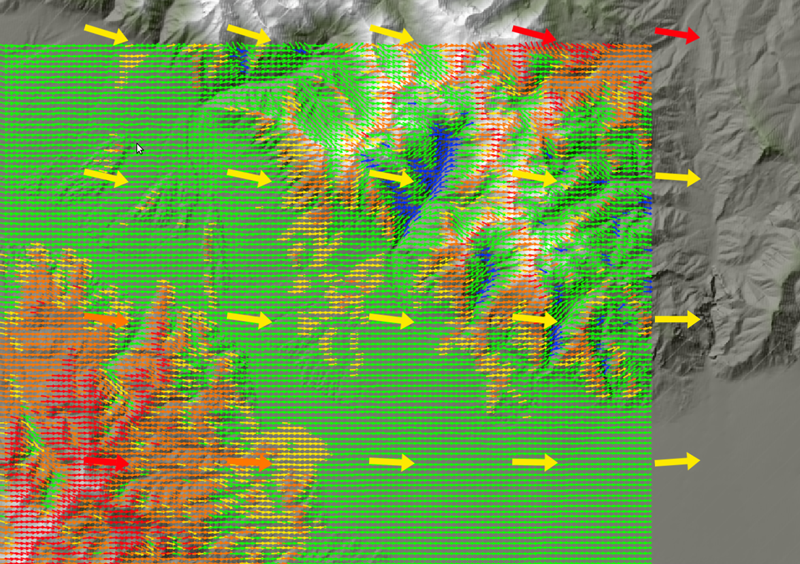
In the first mode, WindNinja can downscale coarser model output and generate simulations of high-resolution wind patterns, accounting for mechanical and thermal effects of the underlying terrain. The result is a granular view of wind conditions, down to a spatial scales of 10s to 100s of m, and out to 168 hrs in the future. This added spatial detail is critical in complex terrain where local wind patterns can differ dramatically from even the most advanced mesoscale forecast models.
WindNinja modeling is used for:
- Driving fire spread models, helping predict fire spread and intensity patterns.
- Supporting situational awareness for crews on the ground and command centers.
- Assisting with accident investigations by reviewing historical wind conditions.
WindNinja is primarily used by wildland fire responders, incident meteorologists, and fire behavior analysts, but as it is open source, anyone can use the application and run simulations. It provides flexibility in how users access and apply the data, and has been helping first responders for two decades to improve their operations and response.
Why Real-Time Observation Data From Synoptic Adds Value
As WindNinja has evolved, Synoptic Data observations were added, providing additional data for users, as well as the ability to easily integrate local observations into simulations. Users can seamlessly connect local weather stations to their area of interest without the need for manual data collection or formatting. This capability significantly expanded WindNinja’s reach, making it more easily usable for anyone, anywhere in the world.
Synoptic has over 170,000 weather stations in its platform from over 320 networks around the globe. The vast amount of data available strengthens WindNinja’s capabilities. By using real-time observations from Synoptic, WindNinja users can quickly link their models to the latest local conditions, enhancing the accuracy of their wind simulations and enabling faster, more confident decision-making.
This collaboration between WindNinja and Synoptic is an example of how public-private partnerships can deliver critical capabilities to the people who need them most. By combining Synoptic’s mission of providing easy access to publicly available environmental data with WindNinja’s advanced wind modeling, the two programs together provide life-and-property-saving information to first responders, researchers, and communities worldwide. Working together to protect lives and property is a service both teams can be proud of.
A Tool for Complex Wildfire Challenges
WindNinja is especially valuable in complex terrain, where wind can channel through valleys, swirl unpredictably over ridgelines, or shift direction rapidly. For wildland fire responders, having access to this level of detail means they can position crews more safely, anticipate sudden changes, and better protect lives and property.
And because it’s open source and publicly available, WindNinja is not just for fire management. It’s also used by researchers, emergency managers, and analysts worldwide to better understand local wind behavior.
In summary, WindNinja turns complex weather into actionable intelligence for those who need it most. And with data integration supported by Synoptic, getting accurate, localized wind information has never been easier, even in the most challenging conditions.
Learn how WindNinja uses Synoptic’s Weather API to bring observations into their system.