



How USPest.org Supports Agriculture Nationwide
With access to weather data from thousands of stations, Oregon State University’s USPest.org helps growers and agricultural professionals anticipate pest activity, manage crop diseases, and make more informed decisions.
What does weather have to do with managing pests in agriculture? Quite a lot, actually. Growing crops comes with plenty of challenges, from unpredictable weather to insects and diseases that can threaten an entire harvest. What many people may not realize is just how closely these challenges are connected.
Environmental conditions such as temperature and moisture influence the timing of events in the life cycles of insects, plants, and plant diseases. Understanding how weather affects the living components of agricultural systems helps growers make more informed decisions about when to monitor for pests, apply treatments, and engage in other time-sensitive activities like harvesting crops. Through better understanding of the close ties between weather and pest management, and looking for ways to support local farmers, the Oregon IPM (Integrated Pest Management) Center at Oregon State University created USPest.org, a weather-driven pest modeling platform.
For 30 years, USPest.org has helped agricultural professionals turn weather observations into practical information about when key pest, disease, and crop events can be expected in their local area. Today, the platform offers approximately 170 predictive models and draws on weather data from thousands of stations across the United States to help growers, consultants, researchers, and extension professionals act with more confidence. Synoptic is proud to support this initiative, supplying weather data for the program.
Turning Weather Data Into Agricultural Decisions
At the heart of USPest.org is a relatively simple concept: weather conditions influence biological development, and understanding those relationships can help predict what happens next.
Many of the platform’s tools use degree-day models, which track accumulated heat over time to estimate the development of insects and other arthropods, crops, and weeds. Rather than relying solely on calendar date estimates, which may not be accurate across regions and years, growers can use the models to anticipate when a particular pest may reach a vulnerable life stage or when a crop may reach an important developmental milestone.
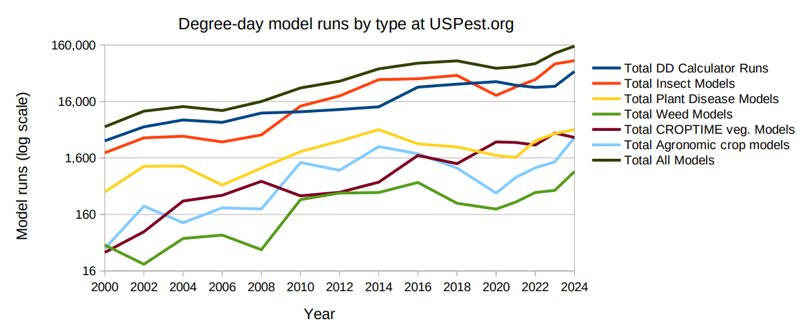
Other models use temperature, humidity, and precipitation to assess the risk of plant infections, helping agricultural professionals determine when conditions may favor disease development. These predictions support decisions such as when to more closely monitor fields, deploy traps, apply treatments, or plan other agricultural activities.
For example, a grower managing codling moths in an apple orchard can use temperature-driven models to better time pest management activities, such as deploying pheromone dispensers for mating disruption or applying ovicides. Models for diseases such as apple and pear scab and grape powdery mildew help growers identify periods when weather conditions may increase infection risk.
The value isn’t simply predicting pest activity. It’s giving agricultural professionals more confidence in deciding when action is needed and when it may not be. In an August 2026 survey of USPest.org subscribers, 99% of respondents reported benefits from the service, including improved pest detection and management, better planning of agricultural activities, and reduced pesticide applications. As one grower explained, the alerts help with, “Expediting sprays or pushing sprays out depending on pressure.”
Why Local Weather Observations Matter
The temperature, elevation, precipitation, and moisture conditions that can influence how quickly pests develop or whether infections occur in plants may vary significantly over relatively short distances. For USPest.org, that makes access to a broad network of weather stations particularly valuable.
The USPest.org platform ingests observations from approximately 40,000 weather stations across more than 225 networks, with Synoptic providing approximately 99% of its weather data. This extensive coverage helps users select stations representative of their fields, orchards, vineyards, or other areas of interest. It also makes the platform useful to agricultural communities in regions where locally developed pest prediction services may be limited.
“Every station is the closest station to some potential user,” explained Len Coop, Associate Professor of Entomology at Oregon State University and longtime leader of USPest.org.
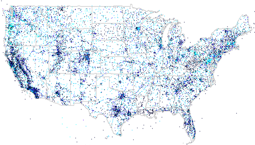
But bringing together observations from so many different sources wasn’t always straightforward. When Coop first launched the platform in 1996, he and programmer Dan Upper had to work with individual weather network operators, establish separate data feeds, and convert observations into consistent formats before the information could be used in their models. Working with Synoptic changed that process considerably.
Today, Synoptic provides a centralized source of weather observations from hundreds of networks, reducing the effort required to collect and standardize data from different providers. As Coop described it, the team can now cover all 50 states with less effort than it once took to cover just five. That efficiency allows the USPest.org team to focus more of its limited resources on developing models, improving tools, and supporting the agricultural communities that rely on them.
From Pest Predictions to Real-World Action
The applications for using real-time data and models for agricultural purposes extend well beyond traditional crop management. In Oregon, the Department of Forestry uses USPest.org’s emerald ash borer forecasts to help determine when to deploy detection traps, replace lures, and remove traps at the end of the monitoring season.
Emerald ash borer is an invasive insect responsible for the destruction of millions of ash trees in the eastern and central United States. Because its immature stages develop inside trees, early detection can be difficult. Weather-driven models help predict when adult insects are likely to emerge, allowing forestry personnel to better time monitoring activities. According to Dr. Wyatt Williams of the Oregon Department of Forestry, the tool has improved the agency’s ability to detect and respond rapidly to emerald ash borer infestations in Oregon’s Willamette Valley by allowing him to alert surveillance cooperators to anticipated adult activity so that traps can be installed before adults emerge. It’s one example of how environmental observations can support decisions that extend beyond forecasting the weather itself.
USPest.org’s tools are also used by university extension programs and agricultural advisors who translate model predictions into recommendations for growers and other stakeholders. The platform’s email notification service, introduced in 2019, takes this a step further by delivering model outputs directly to subscribers. With approximately 350 active users, the service helps agricultural professionals stay informed without having to repeatedly check individual models.
These applications demonstrate how accessible weather observations can support everything from everyday crop management to monitoring invasive species that threaten agricultural and natural ecosystems.
Three Decades of Innovation, With More to Come
USPest.org has come a long way since its beginnings as a regional pest modeling website in 1996. What started with a handful of models and weather networks in the Pacific Northwest has grown into a nationwide resource offering approximately 170 predictive models, weather-based forecasts, spatial modeling capabilities, and automated notifications.
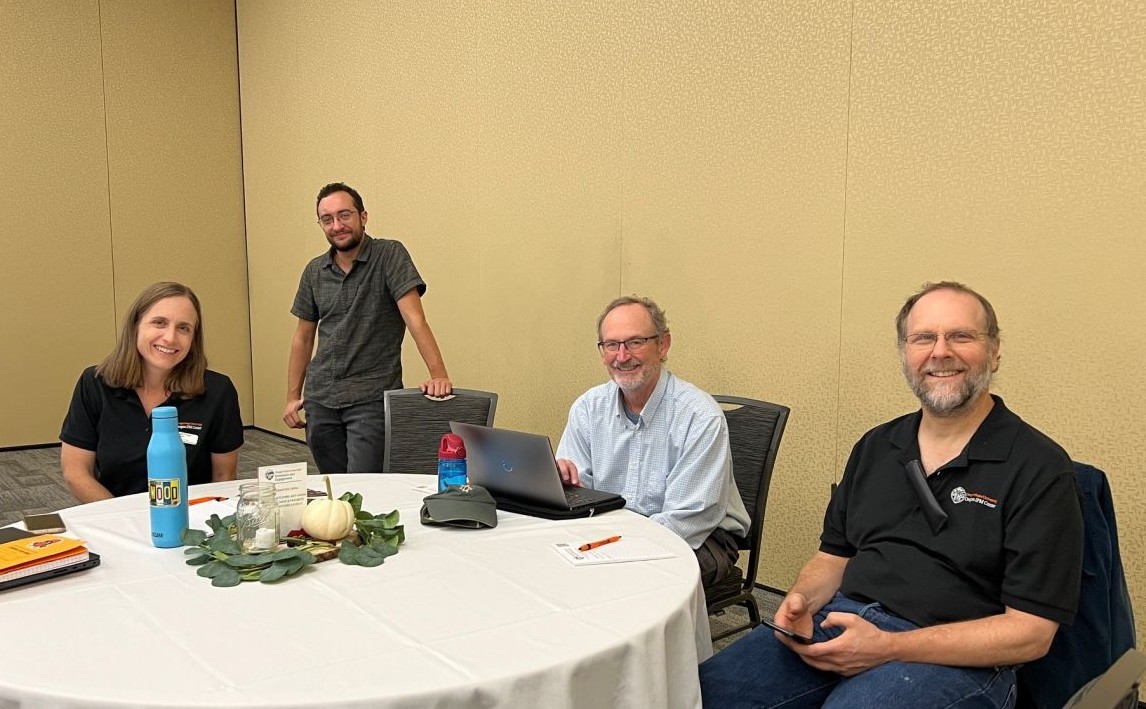
The platform continues to evolve through the work of the Oregon IPM Center’s Decision Support Hub, including Len Coop, programmer Dan Upper, Assistant Research Professor Brittany Barker, and Research Associate Edwin Harris. The team is currently working to modernize the website, simplify access to its tools, and expand the functionality of MyPestPage, a personalized dashboard where users can save models and weather stations of interest.
For Coop, who continues to contribute to the project on a volunteer basis in partial retirement, the motivation remains much the same as it was 30 years ago: making useful scientific information available to the people who need it.
It’s a mission that aligns closely with Synoptic’s commitment as a Public Benefit Corporation (PBC) – making environmental data more accessible and useful for the broader community. By connecting observations from thousands of weather stations to the models and tools developed by USPest.org, Synoptic helps turn environmental data into actionable information that supports growers, agricultural professionals, and the communities that depend on them.
As weather patterns, pest pressures, and agricultural challenges continue to evolve, collaborations like this demonstrate how access to reliable environmental data can make a meaningful difference well beyond traditional weather applications.