RiverAware Expands its Mobile App to Help Communities Stay Ahead of Rising Waters
At Synoptic, our mission is simple: expand access to weather and environmental data so people can make better, safer decisions. That’s why applications like RiverAware are exactly the kind of work we’re proud to support. These innovative applications utilize real-time data for practical, life-saving insights for communities, first responders, and scientists.
When heavy rain begins to fall and river levels rise, having the right information at the right time can make all the difference. The RiverAware app, a mobile application created to help people stay informed about river and flood conditions across the United States, has taken another major step forward with its latest update.
RiverAware combines real-time observations from Synoptic’s Weather API, local news reports, and forecast information to provide personalized flood alerts, empowering users to make timely, informed decisions about evacuating and moving to higher ground. The alignment of technology and mission reflect both RiverAware and Synoptic’s commitment to providing broad, meaningful access to critical data, ensuring it can be used when and where it matters most.
The latest version of the RiverAware app builds on this foundation with new features designed to enhance flood awareness and readiness. The app helps users see what’s happening now, what’s coming next, and how to prepare.
1. National Weather Service Alerts: Critical Updates, Right at Your Fingertips
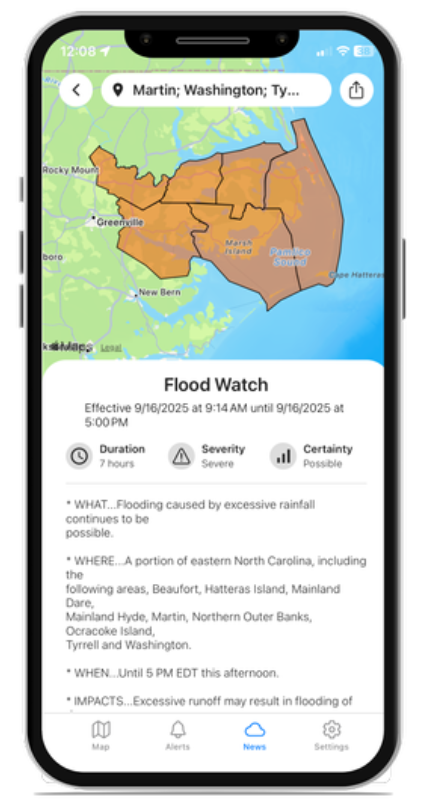
One new addition to the app is the integration of National Weather Service alerts, which now appear directly within the RiverAware interface.
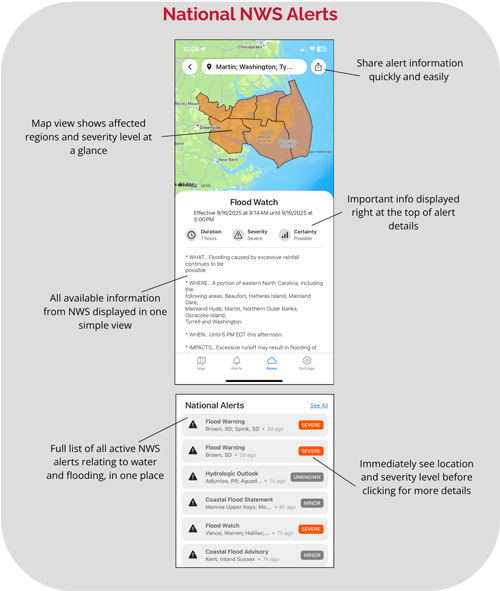
From Flood Watches to Flash Flood Warnings and Coastal Flood Advisories, users can now see all active alerts affecting their area on an interactive map. This includes severity levels and impacted regions clearly displayed. The new map view allows users to visualize how widespread an alert is and quickly assess whether their location may be at risk.
Each alert includes key details such as its duration and severity, as well as the full text issued by the National Weather Service. For those tracking multiple regions, such as emergency managers, outdoor recreation leaders, or families with loved ones in different areas, this makes it easier than ever to stay informed about local threats because all of the information is in one place.
The new alert feature also enhances situational awareness at a glance. Users can immediately see where alerts are in effect, share critical information with others, and access official guidance without leaving the app.
2. River Forecasts: Seeing What’s Coming Next
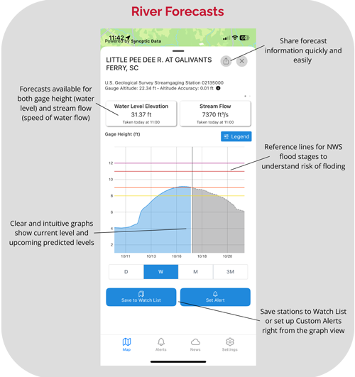
In addition to real-time alerts, RiverAware now provides forecast data from the National Weather Service’s River Forecast Centers.
These forecasts help users understand the current river levels, as well as how they’re expected to change over the next several hours or days. With this information, communities can prepare for rising waters before they become a threat, and decision-makers can plan with greater confidence.
River forecasts are particularly valuable during prolonged rain events or snowmelt seasons when rivers can rise gradually but significantly. By displaying forecast data in the same place as live gauge readings and flood alerts, RiverAware gives users a complete, forward-looking view of river behavior where available from the National Weather Service.
3. Flood News Feed: Context from Across the Country
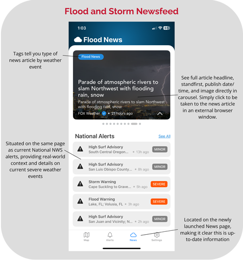 Patterns of heavy rainfall, regional weather systems, and extreme events can have ripple effects across states and watersheds. RiverAware’s new news feed feature brings national context to local awareness. The news feed within the app curates stories from mainstream media sources covering significant flooding events or expected heavy rainfall. For users who want to track how ongoing storms are evolving across the country, the news feed provides an at-a-glance source of trusted updates.
Built on Real-Time Data — Powered by Synoptic
While RiverAware’s new features focus on forecasts, news, and alerts, Synoptic continues to play a key role behind the scenes.
Along with the new features, the app utilizes Synoptic’s extensive environmental data platform, which integrates real-time observations from thousands of river, weather, and hydrologic sensors across the United States and beyond. Through Synoptic’s Weather API, RiverAware accesses a unified stream of current river levels, precipitation, temperature, wind, and other critical parameters, all sourced from trusted networks.
This foundation of consistent, quality-controlled data enables RiverAware to display the most up-to-date information possible. It helps empower users with real-time data alongside live river tracking, flood monitoring, and NWS alert overlays.
Making a Difference Through Data
Flooding remains one of the most costly and dangerous natural disasters worldwide. According to the National Weather Service, floods cause more deaths each year in the U.S. than any other weather-related hazard. Awareness and early information can mean the difference between safety and disaster.
By combining authoritative alerts, accurate forecasts, and real-time data visualization, RiverAware helps bridge that gap. And by supporting the data infrastructure that makes such applications possible, Synoptic is proud to be part of the solution — helping organizations, developers, and innovators bring life-saving information directly to those who need it most.